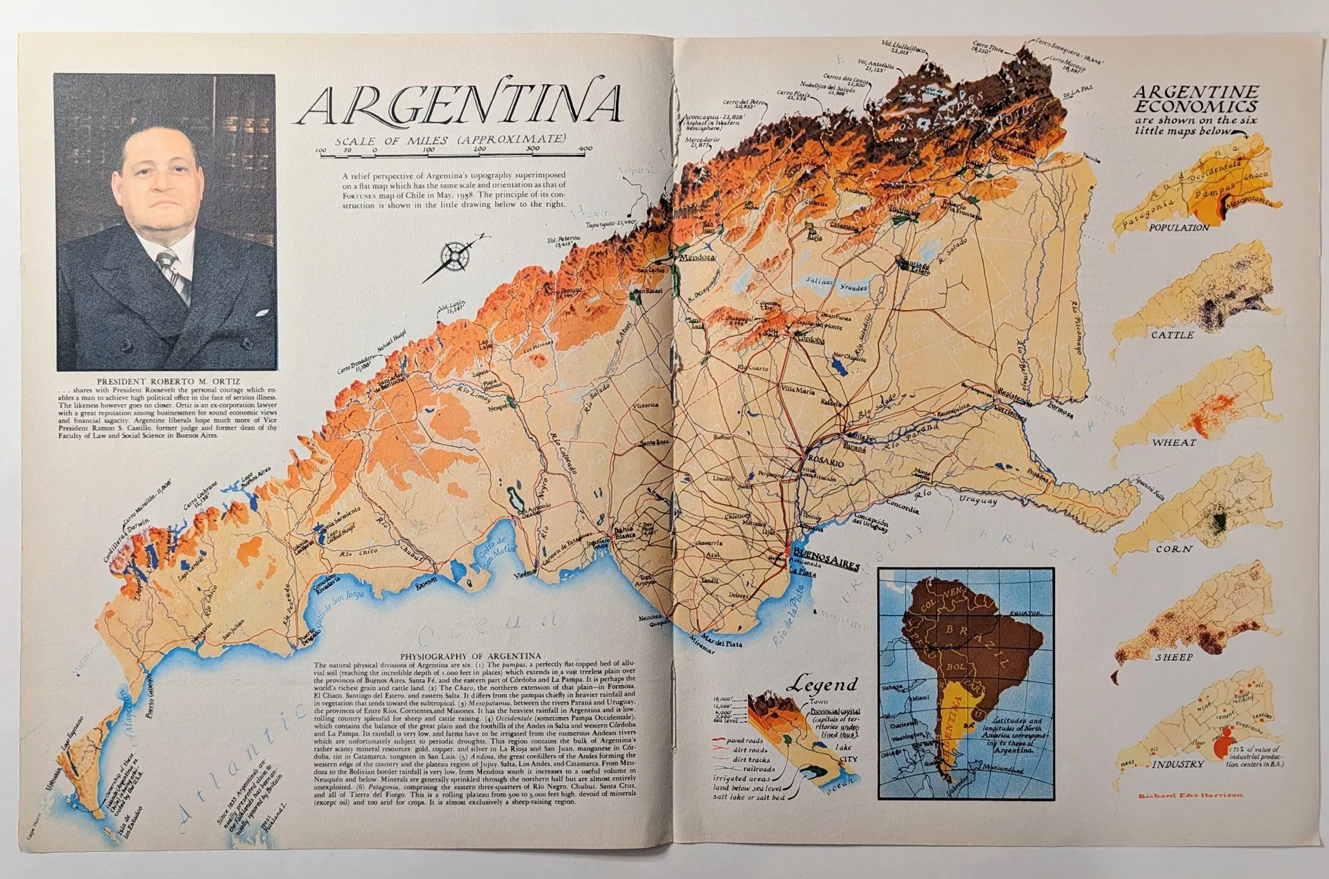
1938 FORTUNE Argentina Relief Map by Richard Edes Harrison
In 1938, FORTUNE magazine printed Argentina as a mountain range exploding off the page. This two-page spread is a relief-perspective map of the country by Richard Edes Harrison, the architect-turned-cartographer who was reinventing how Americans saw the world from FORTUNE's art department. The Andes rise in three-dimensional brown and orange along the Chilean border while the Pampas flatten into pale yellow below, and six small inset maps along the right edge chart the country's economy in population, cattle, wheat, corn, sheep, and industry. A portrait of President Roberto M. Ortiz occupies the upper left, and Harrison's printed credit sits at lower right. The exact issue has not been confirmed from the copy photographed, but the map's own text dates it: it cites FORTUNE's Chile map of May 1938 as already published, and it presents Ortiz as the sitting president, an office he assumed on 20 February 1938 [S2][S3]. The working range is therefore mid-1938 or later; no month is claimed here. Read closely, the page is a small machine for persuasion. The main caption explains the method honestly: "A relief perspective of Argentina's topography superimposed on a flat map which has the same scale and orientation as that of FORTUNE's map of Chile in May, 1938." A compass rose, a scale of miles, and a full legend decode the symbols — paved and dirt roads, railroads, irrigated areas, land below sea level, salt beds — while a long "PHYSIOGRAPHY OF ARGENTINA" essay divides the country into six natural regions, from the Pampas, "perhaps the world's richest grain and cattle land," to Patagonia, "almost exclusively a sheep-raising region." The Ortiz caption is pure 1938 business-press editorializing: it praises the president's "personal courage" in facing serious illness, compares him to Roosevelt, and reports that "Argentine liberals hope much more of Vice President Ramon S. Castillo." These are FORTUNE's words, quoted here as evidence of the magazine's voice — not as settled historical fact. The historical setting is the hinge moment before the Second World War, when the United States business establishment was discovering Latin America as strategy, not scenery. FORTUNE, founded by Henry Luce in 1930, ran an ambitious South America program in 1937 and 1938: Harrison's foldout "South America in Globular Perspective" had accompanied the December 1937 article "To South America and Back" [S6], and the Chile and Argentina relief maps continued the series into 1938 [S3]. Harrison himself had come to cartography by chance in 1932, joined FORTUNE's staff from 1936 to 1938 [S1], and brought an architect's eye — Yale fine-arts training, drafting work for Cass Gilbert — to a field still ruled by the Mercator projection [S5]. His tilted, pilot's-eye views broke the north-always-up convention, and the wartime maps that followed — "The World Divided" (August 1941), "One World, One War" (March 1942), the latter ordered in 18,000 copies by the US Army [S4] — made him one of the most influential American mapmakers of the decade. His azimuthal projection work even influenced the design of the United Nations logo [S1]. Visually, the spread is built for a reader FORTUNE flattered as a man of affairs. The giant title "ARGENTINA" is hand-lettered in an engraved roman; the relief shading borrows the language of physical geography textbooks; the six economic insets reduce a national economy to dot densities a busy executive could absorb in seconds. The most cunning device is the small locator map at lower right: South America folded back along the equator over North America, captioned "Latitudes and longitudes of North America corresponding to those of Argentina," with Habana, Miami, Charleston, Washington, New York, Chicago, Quebec, and Labrador marked for orientation. It is a rhetorical argument disguised as a reference tool — Argentina is not exotic, it says; it sits exactly where you sit, latitude for latitude. Harrison had used the same folding device on the December 1937 foldout [S6]; here it does the quiet work of making a distant country strategically legible to an American reader. The documentary significance is twofold. First, as cartographic art: this is Harrison at his 1938 peak, in the series that taught American readers to see terrain as three-dimensional space rather than flat outline — the visual grammar that would carry US strategic thinking through the war. Second, as a period document: the Ortiz portrait, the physiography essay's confident resource inventories, the "75% of value of industrial production centers in B.A." callout on the industry inset — these show how the American business press framed Argentina on the eve of war, a few years before Ortiz's failing health forced him to delegate power to Castillo in 1940 [S2]. The map flatters its subject; the flattery is the evidence. In the curator's reading, the spread's power comes from the tension between its two registers: Harrison's genuinely innovative cartography, and FORTUNE's editorial voice using that cartography to sell a worldview. The relief is honest about its own construction; the prose is not always honest about its subject. That is precisely why the piece belongs in an archive: it preserves both the innovation and the persuasion on a single sheet of 1938 paper. What remains unresolved is the exact issue and whether a longer Argentina article traveled with the map [GAP-01][GAP-02]; the rarity assessment below reflects that the object is judged on what is verified, not on what is wished. References / Sources [S1] Wikipedia, "Richard Edes Harrison" — biography, FORTUNE staff 1936-1938, map series, UN logo influence. https://en.wikipedia.org/wiki/Richard_Edes_Harrison [S2] Wikipedia, "Roberto M. Ortiz" — presidency from 20 February 1938, illness, resignation June 1942. https://en.wikipedia.org/wiki/Roberto_M._Ortiz [S3] Neatline Maps — Harrison "Chile" map, May 1938, part of FORTUNE South America series. https://neatlinemaps.com/antiquemap/nl-01039/richard-edes-harrison-chile/ [S4] Cornell University Library, PJ Mode Collection — "One World, One War" (March 1942), 18,000 copies ordered by the US Army. https://digital.library.cornell.edu/catalog/ss:3293939 [S5] RareMaps.com — Richard Edes Harrison dealer biography, architect training. https://raremaps.com/mapmaker/9460/Richard_Edes_Harrison [S6] AbeBooks dealer listing — Harrison "South America in Globular Perspective," FORTUNE foldout, December 1937. https://www.abebooks.com/maps/South-America-Globular-Perspective-looking-Northwest/31192452556/bd Further reading: Susan Schulten, "Richard Edes Harrison and the Challenge to American Cartography," Imago Mundi 50 (1998), 174-188.
Category: Art & Museums
Year: 1938
Rarity Class: A
Paper & Print Condition
Examined from photographs only; no direct physical inspection has been recorded for this draft. The object is a two-page magazine spread, photographed as a single flat sheet with both pages visible and the center gutter running vertically. Printing is consistent with FORTUNE's 1930s offset lithography: full-color relief shading on the main map, black text, and a halftone portrait.
From the images, the sheet appears complete with all four edges visible and no major tears or losses. Light age-toning is visible in the margins, normal for 1930s coated magazine stock. The gutter shows the expected binding fold with minor stress; no separation is visible at this resolution. Colors remain strong in the relief areas — browns, oranges, and blues read as saturated, suggesting the sheet was kept from prolonged light exposure.
Not verified from images: paper weight, exact dimensions, verso content, and whether the leaf is a bound-in original or a detached plate. A direct examination should confirm these before any condition grade is assigned.
Provenance & Rarity
Published as an editorial map spread in FORTUNE magazine, Time Inc., New York. The exact issue is unconfirmed; internal evidence bounds it to no earlier than mid-1938 — the map cites FORTUNE's Chile map of May 1938 as already published and presents Roberto M. Ortiz, president from 20 February 1938, as the sitting president. The cartographer is credited in print on the object itself: "Richard Edes Harrison."
No acquisition documentation was supplied for this draft; the photographs come from the curator's own archive. The object is consistent with an original period printing — the printing characteristics, period typography, and contemporary editorial text match a 1938 magazine leaf — though direct physical examination would be needed to rule out a later facsimile.
Rarity class A, curator-assessed under the standing TRI methodology: base class B for a 1930s FORTUNE gatefold, with the +1 uplift for a verified printed creator credit (the same rule applied to the January 1952 Harrison map in this collection). No survival census exists for this specific sheet, so the assessment reflects curatorial judgment on scarcity and significance, not a counted population. The 1938 date places it in Harrison's peak FORTUNE period and in the magazine's pre-war South America series, which supports the assessment on significance independent of scarcity.
Rarity & Condition Summary