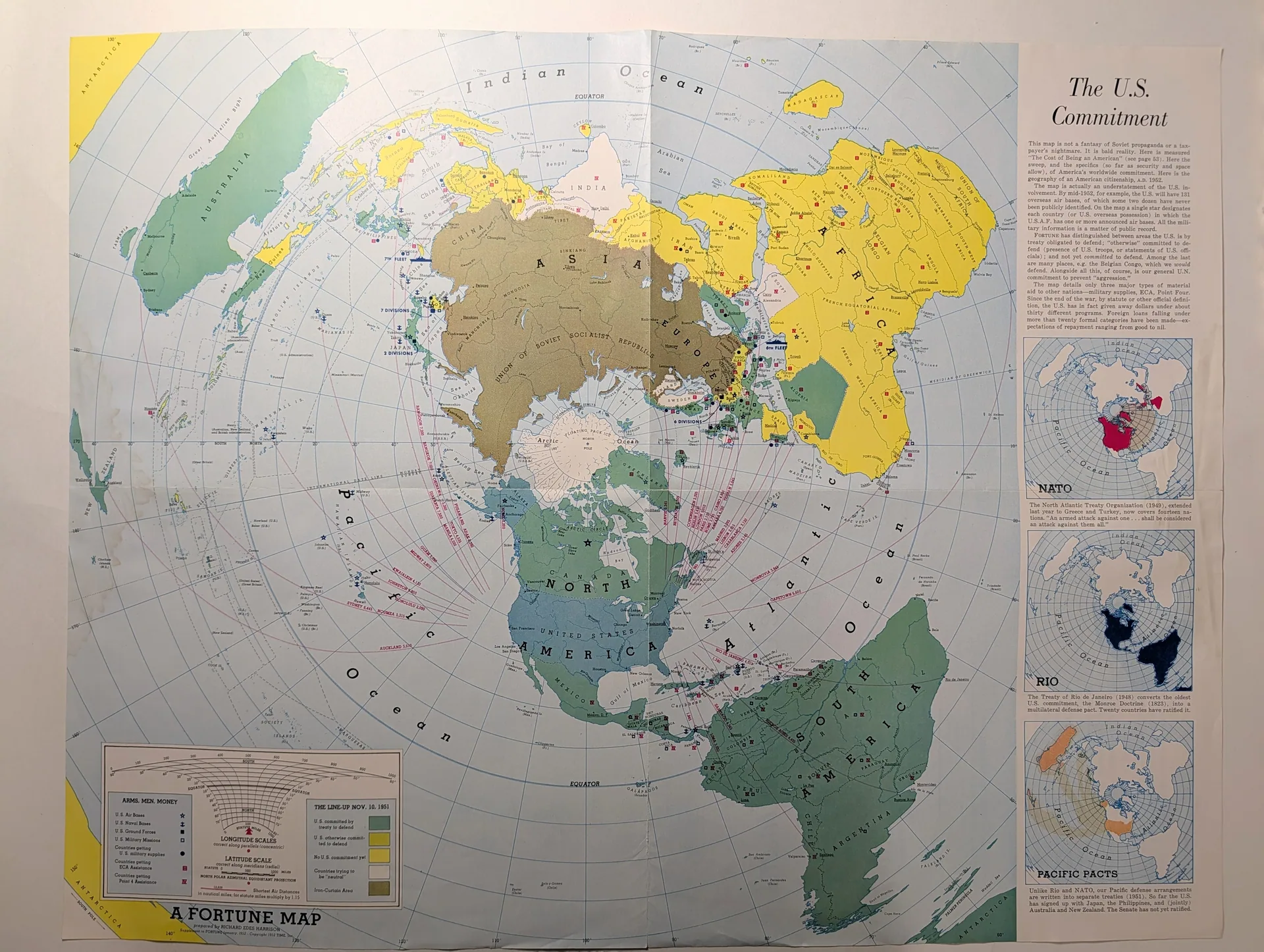
1952 FORTUNE "The U.S. Commitment" Map Supplement by Richard Edes Harrison
“The U.S. Commitment,” a foldout editorial map supplement to the January 1952 issue of FORTUNE, subtitled “the geography of an American citizenship, A.D. 1952.” Drawn by the celebrated cartographer Richard Edes Harrison on a North Polar Azimuthal Equidistant Projection, it charted American treaty commitments — NATO, the Rio Pact, and Pacific pacts — at the height of the early Cold War. This is an editorial cartographic artifact, not an advertisement. By January 1952 the United States was three years into the North Atlantic Treaty, two years into the Korean War, and months away from the first thermonuclear test. FORTUNE, founded in 1930 as a business magazine of unusual visual ambition, had made maps a signature of its journalism — and its cartographer, Richard Edes Harrison, was the most famous mapmaker in American publishing. Harrison's innovation was perspective: his polar-centered projections, first developed during the Second World War, forced American readers to see the world as a single strategic space rather than as the familiar Mercator strip in which the Soviet Union sat at an unthreatening distance. “The U.S. Commitment” applied that method to the new alliance architecture. Drawn on a North Polar Azimuthal Equidistant Projection, the map displayed the United States' treaty obligations as geography: NATO across the North Atlantic, the Rio Pact across the Western Hemisphere, and the network of Pacific pacts across Asia and Oceania. The legend was headed “THE LINE-UP NOV. 10, 1951,” freezing alliance status as of that date. The subtitle, “the geography of an American citizenship, A.D. 1952,” made the editorial argument explicit: alliance commitments were being recast as obligations of citizenship itself. As an object, this is a mass-circulation magazine supplement: printed in the large numbers FORTUNE commanded and distributed inside every copy of the issue. The map's significance is contextual and documentary: a dated, named, authorial statement of how American power visualized itself at the moment the Cold War's alliance system became permanent. BRAND / PUBLISHER: FORTUNE (TIME, Inc.). PRODUCT: Editorial map supplement: “The U.S. Commitment”. NOTE: This CMS has no dedicated brand/publisher field for maps — record here. IMAGE ALT TEXTS (PER IMAGE): (1) 1952 FORTUNE The U.S. Commitment map supplement by Richard Edes Harrison; (2) 1952 FORTUNE The U.S. Commitment map, legend and imprint detail; (3) 1952 FORTUNE The U.S. Commitment map, title panel detail; (4) 1952 FORTUNE The U.S. Commitment map, NATO inset detail; (5) 1952 FORTUNE The U.S. Commitment map, Rio Pact inset detail; (6) 1952 FORTUNE The U.S. Commitment map, Pacific Pacts inset detail; (7) 1952 FORTUNE The U.S. Commitment map, title page detail. (CMS has only one shared alt-text field; put alt text for image 1 there and list all 7 here.) TECHNICAL DETAILS Rarity Class: A — Evidence (research v2): bound into every copy of FORTUNE January 1952 (Time Inc. mass circulation). Editorial cartography credited to Richard Edes Harrison, the era's most significant American news cartographer; foldout attrition adds plausible scarcity. Owner's standing rule: credited editorial creators earn +1 class. GPT+Claude consulted; curator-adjudicated.
Category: Art & Museums
Year: 1952
Rarity Class: A
Paper & Print Condition
Large foldout map; color lithographic printing. Fold intersections are the vulnerable points — check for separations and tears at cross-folds. Not assessed from photographs.
Provenance & Rarity
Provenance unknown. FORTUNE supplement, January 1952; cartographer credited on the map. No scarcity documentation; rarity class A.
Rarity & Condition Summary
TRI rarity class A: historically significant Cold War cartography by Richard Edes Harrison, but a mass-circulation supplement with unverified survival. Condition to be confirmed on physical intake. The credited editorial cartographer Richard Edes Harrison earns +1 class per the owner's standing rule honoring credited creators.