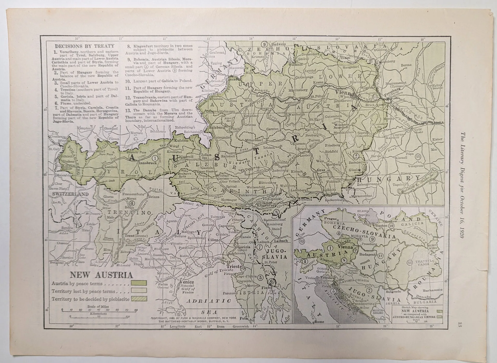
1920 The Literary Digest New Austria Treaty Map Page
*Paragraph 1 — Visual Description:* The supplied images show a single landscape magazine leaf: a hand-colored political map of central Europe in a heavy double-ruled black frame, surrounded by wide unprinted margins. The map base is dense black linework: heavy broken lines for boundaries, fine lines for rivers, and a light graticule with degree figures (46°, 45°; 10°–18° east of Greenwich). Cities are small open circles in a compact serif — Vienna, Innsbruck, Salzburg, Graz, Klagenfurt, Budapest, Prague, Trieste, Venice, Bucharest, Belgrade among the legible names — and rivers take an italic hand, the Danube, Adige and Po prominent. Regions carry large spaced capitals: TYROL, SALZBURG, STYRIA, CARINTHIA, UPPER AUSTRIA, LOWER AUSTRIA, HUNGARY, GALICIA, CZECHO-SLOVAKIA, JUGO-SLAVIA, ROUMANIA, TRENTINO and the ADRIATIC SEA. Three color treatments distinguish territorial status: a mid olive-green wash over territory retained by Austria under the peace terms, a pale grey-green wash over territory lost, and a diagonal green hatch over zones awaiting plebiscite, notably around Klagenfurt and in Silesia; the wash varies in density, pooling darker at field edges. Thirteen numbered paragraphs under the header "DECISIONS BY TREATY" run across the upper right and down the right margin, keyed to circled numerals on the map face. A legend panel at left center keys the three treatments to "Austria by peace terms," "Territory lost by peace terms" and "Territory to be decided by plebiscite," above a dual bar scale, "Scale of Miles" (0–80) and "Kilometers" (0–100). A framed inset at lower left — "Sketch Map showing NEW AUSTRIA as compared with AUSTRO-HUNGARIAN EMPIRE," with its own 0–100 scale — reduces the two outlines to a simplified comparison. The full-page view shows a patch of surface roughness near the center of the lower edge, and the unprinted margins carry an even, light age-toning. *Paragraph 2 — Printed Text & Marks:* The title "NEW AUSTRIA" stands in large serif capitals over the legend panel; the header "DECISIONS BY TREATY" introduces thirteen numbered entries, as legible: 1. Vorarlberg, northern and eastern Tyrol, the main part of Salzburg, Upper Austria and part of Styria forming the main part of the new Republic of Austria; 2. Part of Hungary forming the balance of Lower Austria; 3. Balance of Lower Austria; 4. Trentino (southern part of Tyrol) to Italy; 5. Gorizia, Istria and part of Dalmatia to Italy; 6. Fiume, undecided; 7. Part of Styria, Bosnia, Herzegovina, Croatia, Dalmatia and Slavonia forming part of the new Republic of Hungary, Jugo-Slavia; 8. Klagenfurt territory in two zones subject to plebiscite; 9. Bohemia, Austrian Silesia, Moravia; 10. Czecho-Slovakia; 11. Part of Hungary; 12. Galicia to Poland; 13. The Danube from Ulm downstream internationalized, with the Austrian boundary noted. The legend, the two scales, and the inset caption are transcribed in ¶1. The credit beneath the Adriatic reads: "COPYRIGHT, 1920, BY FUNK & WAGNALLS COMPANY, NEW YORK" on one line and "THE MATTHEWS-NORTHRUP WORKS, BUFFALO, N. Y." on the next. Along the lower frame runs "12° Longitude East 13° from Greenwich." The page footer reads "The Literary Digest for October 16, 1920," and the numeral "13" appears at the foot of the leaf. Under the designation-parsing rule, the printed "13" supports page number 13 and nothing further. The copyright line separates into two statements: Funk & Wagnalls Company of New York as printed copyright holder, and The Matthews-Northrup Works of Buffalo, New York, as the firm credited on the map. No illustrator signature is resolvable at the supplied image resolution; this is a limit of the reproduction, not evidence that none was printed. *Paragraph 3 — Maker Context:* The map is unsigned, and its cartographer is unidentified. The printed credits name two entities, each treated here at the minimum the credit supports. "FUNK & WAGNALLS COMPANY, NEW YORK" is the printed copyright holder; the footer identifies the sheet as a page of The Literary Digest, making Funk & Wagnalls the publishing house behind the periodical on the artifact's own evidence (the firm's wider history requires downstream verification). "THE MATTHEWS-NORTHRUP WORKS, BUFFALO, N. Y." is the cartographic firm credited on the map face; whether it engraved the plate, printed the color, or produced the map outright cannot be determined from the credit line alone and requires downstream verification. The sheet carries no engraver's monogram, no plate number, and no separate printer's imprint beyond these two lines. *Paragraph 4 — Geographic & Audience Context:* Printed credits place production in New York (publisher) and Buffalo (map works), both in the United States. Its footer identifies it as a page of The Literary Digest for October 16, 1920 — a New York weekly condensing the week's news for American general readers (format and readership are interpretive, drawn from the object, requiring downstream verification). The map's subject is the territorial settlement imposed on Austria after the First World War — the peace terms of the Treaty of Saint-Germain-en-Laye, signed in September 1919 (treated here as an independent historical fact requiring verification). Its internal dating evidence is precise: the Klagenfurt zone is marked "in two zones subject to plebiscite" and Fiume "undecided," recording the settlement as an unfinished process. The dual mile/kilometer scale and the longitude reckoned "from Greenwich" address an American readership being taught to read a European map on its own terms. *Paragraph 5 — Visual Language Analysis:* The visual language is functional news cartography of the early 1920s: maximum information density through a disciplined hierarchy of line weight, letter-spacing, and one green in three treatments. The thirteen numbered decisions, cross-keyed to circled numerals on the map face, translate a legal-diplomatic text into a visual index — a summarization device that taught readers to absorb a complex settlement in a single page. The hand-applied quality of the color — a watercolor wash with visible pooling — belongs to a cartographic craft tradition in which magazine maps were tinted by hand over an engraved or lithographed key, a labor-intensive finish reserved for special explanatory pages (possible formal resonance with Arts and Crafts — see field 19). The heavy double rules, geometric graticule, bold block lettering of "NEW AUSTRIA" and the inset title, and high-contrast planar black-and-green blocks share the visual language of the early-1920s geometric idiom (possible formal resonance with Proto–Art Deco / Style moderne (anticipatory) — see field 19). *Paragraph 6 — Function & Archival Significance:* The sheet functioned as explanatory journalism: a one-page visual summary letting a weekly's readers follow the redrawing of central Europe without an atlas. Its thirteen-point structure mirrors the digest method, and its hand coloring marks a page meant to be studied, not skimmed. What the artifact documents that other sources do not is the settlement's provisional state as presented to the American public in October 1920: Fiume labeled "undecided," Klagenfurt hatched for a plebiscite, the Danube's internationalization itemized as a numbered decision. The leaf is photographed as a loose sheet; its original assembly cannot be inferred from its present state, and the roughness of its lower edge is consistent with handling of several kinds, none of which is asserted here.
Category: Art & Museums
Year: 1920
Rarity Class: B
Paper & Print Condition
The black map key — boundaries, lettering, graticule, and the thirteen decision paragraphs — appears visually crisp at the supplied resolution, with line weights stepping clearly from hairline rivers to the heavy double-ruled frame. Color is carried by washed green tints laid over the key: the legend swatches and the territorial fields show uneven wash density with darker pooling at field edges, consistent with hand-applied watercolor rather than a mechanically printed tint. The paper reads as a cream or off-white wove stock with an even, light age-toning across the unprinted margins; the full-page view shows a patch of surface roughness near the center of the lower edge and minor irregularity along the sheet edges. Likely process: probable hand-applied watercolor wash over an engraved or lithographed black key (physical examination required for confirmation). Confidence: Moderate. A plausible alternative is a machine-printed tint laid from separate lithographic stones, which is ranked less likely because the wash density varies visibly within single fields — positive evidence for hand application. Minimum distinguishable colour separations resolvable in the supplied image: 3 (black key, mid olive-green wash, pale grey-green wash; the diagonal plebiscite hatching appears to be printed in the black pass). This is a floor, not a count. No handling or storage history is inferred from the observed toning and edge roughness.
Provenance & Rarity
Source media observed: a single magazine leaf identified by its own footer as page 13 of The Literary Digest for October 16, 1920, photographed as a loose sheet. The original acquisition record, prior ownership, and the circumstances under which this leaf left its issue are undocumented in the supplied material: [AWAITING CURATORIAL ASSIGNMENT]. No rarity assessment is made here: [AWAITING CURATORIAL ASSIGNMENT — C–OMEGA scale]. No comparative survival claim is advanced for magazine map leaves of this period without documented holdings data.
Rarity & Condition Summary
The leaf presents as an intact single sheet with legible color and crisp linework; the unprinted margins carry an even, light age-toning, and a patch of surface roughness is visible near the center of the lower edge in the full-page view. The washed color fields remain distinguishable in their three treatments, and the printed text — including the thirteen treaty decisions, legend, scales, and copyright line — is fully legible at the supplied resolution. The double-ruled frame holds continuous around all four sides in the full-page view, and the inset sketch map with its legend remains fully legible. The rarity half of this summary is [AWAITING CURATORIAL ASSIGNMENT]; nothing in the observed condition is used here to imply scarcity or to grade the object.